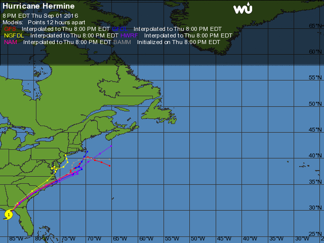
 Storm track of Hermine at 8:00 p.m. 9/1. Image, Weather Underground
Plans don't always work out as we hope. Our hope for today's musings on all things Outer Banks was to write about the WRV Outer Banks Pro Surf Competition at Jennette's Pier.
But then reality got in the way and Hurricane Hermine formed in the Gulf of Mexico and all signs point to it running parallel to the coast before it reaches the Outer Banks as Tropical Storm.
All the guidance tracks are in remarkable agreement that the center of the storm will stay over land until it exits somewhere over the northern Outer Banks. Actually, peering closely at the storm track it looks almost as though it will exit right about Kitty Hawk.
Here's the lowdown on tropical storms—it will be 14-16 hours of wretched weather. This one in particular looks as though it's going to be a real rain maker, with the latest forecast predicting 7"-8" of rain from Friday into Saturday.
Here's the other part to the other part to that—the forecasts have been a little bit inconsistent over the past two days, although the agreement on the path of Hermine has become very consistent.
One track, the NGFDL, is to the west or inland compared to all the others. From the standpoint of tropical systems and how they behave, that's the one we'll hope is the most accurate—although truth in reporting compels us to note that is the only forecast track that is outside the envelope. However, if Hermine does follow that track, there would probably be more weakening of the storm since it would be farther away from the Atlantic Ocean where it draws its energy.
It would also have less impact on the Outer Banks...but that doesn't really seem like what's going to happen.
#joelambjr